
New driverless shuttles, trams and extra train station feature in ambitious travel plans for Northampton

A major new transport strategy has set out a vision for how Northampton could travel by 2036 and beyond – from new tram-style mass transit and orbital bus links to major walking and cycling routes, mobility hubs and upgraded roads.
West Northants Council’s draft Northampton Area Transport Strategy looks ahead to 2036 and beyond, with 155 potential improvements assessed and 61 identified as priorities for further development and potential funding.
The report says around 75 per cent of journeys to work in Northampton are made by car, compared with 13 per cent walking or cycling, eight per cent by bus or coach and one per cent by train.
The council’s says its vision is: "By 2035, Northampton has become a rapidly expanding town with an increasing need for alternative, high-quality, sustainable transport provision to the private car.

“Working together with our communities we have made travel by active modes like walking and cycling the natural first choice for short trips, travel by public transport has become increasingly attractive and accessible, and communities are less dependent on private cars.
“More resilient infrastructure and services increase opportunities for people to live their best lives by facilitating a vibrant town centre and local neighbourhoods, and a thriving local economy.”
Reform councilor Richard Butler, cabinet member for highways and transport, said: "Anyone who travels around Northampton knows there are times when the network comes under pressure.
“As the town continues to grow, we need to think carefully about how people get to work, school, the shops and other key destinations.
"We're looking at ideas that could improve bus services, make it safer and easier to walk and cycle, and help tackle congestion in some of the busiest parts of the town.
"Nothing has been decided yet, which is why we're asking people to take a look at the proposals and tell us what they think.
“Local knowledge is incredibly important, and we want residents to help shape these plans."
Here are some of the key ideas from the 130-page report…
Harborough Road
Priority: High
The A508 Harborough Road is one of the main corridors targeted.
Plans include improved walking and cycling routes, bus priority measures and mobility hubs at Harborough Road/Welford Road in Kingsthorpe and Harborough Road/White Hills Crescent in Whitehills.
A larger mobility hub on Harborough Road could also include a park and ride.
The strategy also includes the walking and cycling route between Kingsthorpe and the A45 Queen Eleanor interchange.
The report says: “A package of component interventions to improve the reliability of bus services and attractiveness to users along the Harborough Road corridor leading into Northampton Town Centre.”
It says the package could include lane changes, yellow box junctions, banned turns, reviews of parking restrictions, bus stop improvements and better nearby crossing facilities.
Harborough Road is identified as one of two higher-priority corridors expected to advance first.
Kettering Road, Moulton and Overstone
Priority: Medium to High
A similar package is proposed along the A43/Kettering Road corridor, covering Spinney Hill, Moulton Park, Moulton, Overstone and Sywell.
Possible mobility hubs have been identified at:
- Kettering Road near Morrisons, Spinney Hill
- Kings Park Road, Moulton Park
- High Street Co-op, Moulton
- Sywell Road, Overstone
- Overstone Road, Sywell
There could also be a larger transport hub and park and ride on the A43 Kettering Road, plus a walking and cycling route between the town centre and Moulton.
Kettering Road is also earmarked for a Bus Smart Corridor.
The report says the package is intended to provide “improved sustainable travel choices along the A43/Kettering Road corridor”, linking the town centre with Spinney Hill, Moulton Park, Moulton, Overstone and Sywell.
The report says the measures could include mobility hubs, park and ride and the town centre-to-Moulton walking and cycling route.
North and north-east Northampton
Priority: Medium to Medium-High
The strategy proposes better connections between suburbs, including King's Heath and Moulton Park, without requiring every journey to pass through the town centre.
It also looks at traffic management in Moulton and Boughton villages.
Further east, mobility hubs and walking and cycling improvements are proposed around Southfields, Goldings, Lings, Thorplands, Blackthorn and Rectory Farm.
The plans include better crossings and routes around Great Billing Way, Lings Way and Talavera Way.
The report says the package would provide “better east-west connections across the north of Northampton”, including improvements between King’s Heath and Moulton Park, alongside traffic management in Moulton and Boughton.
The report says further work will be needed to determine the preferred approach.
For Talavera Way, the report goes into more detail, including improved access to existing footbridges and underpasses, better lighting and improved routes for pedestrians and cyclists.
North orbital road
The strategy does not propose a new northern orbital road around Northampton.
The report looked at different options for a new north orbital route, but the larger new-road alternatives were dismissed.
Instead, the strategy focuses on making better use of existing roads, including possible bus priority, junction improvements and traffic management, alongside better walking, cycling and public transport links between the northern suburbs.
The report says the aim is to improve connections between areas such as King's Heath, Kingsthorpe and Moulton Park without requiring journeys to go through the town centre.
This sits alongside the proposed orbital public transport links between King's Heath, Kingsthorpe and Moulton Park, and other parts of north and east Northampton.
Weston Favell
Priority: Medium to Medium-High
A town mobility hub at Weston Favell Shopping Centre is proposed, alongside improvements around A43 Lumbertubs Way.
The package also includes a core walking zone and a walking and cycling connection between Southfields and Weston Favell.
The report says the Weston Favell package combines a mobility hub at the shopping centre with measures to tackle the “severance” caused by A43 Lumbertubs Way, a core walking zone and the Southfields-to-Weston Favell cycling and walking route.
The mobility hub could include better bus shelters, seating and passenger information, footway access, crossings, a micro-mobility hub and cycle parking or storage.
Brackmills, Delapré and the town centre
Priority: Medium to High
A major walking and cycling route could connect Brackmills Industrial Estate and Northampton town centre.
The proposed route would be mainly traffic-free, using greenway sections and the A45 underpass, with links through Delapré and into the town centre.
The report says: the route would repurpose the former railway line as a “high quality active mode route” linking Brackmills Industrial Estate at Burryport Road with Northampton Railway Station car park and Green Street.
The report breaks the route into three sections – Burryport Road to Cotton End, Cotton End to Towcester Road, and Towcester Road to Northampton Railway Station.
It also says new ramp accesses would be needed to connect the route with local roads and that it would include lighting, signage and seating.
Another proposed route would connect Northampton town centre, the railway station, Sixfields and Upton.
Town centre
Priority: High for several major schemes
The strategy proposes a Town Centre Walking Zone and Movement Plan, alongside improvements at Abington Square, Plough Junction and around the town centre ring road.
The report says the walking zone would focus on “making it easier and safer to walk, wheel and cycle into and across the centre” and would help connect regeneration sites and reduce barriers created by busy roads.
The separate town-centre package includes public realm improvements at Abington Square, changes at Plough Junction and traffic signal optimisation around the ring road.
The strategy also includes improvements around Northampton railway station and the bus and coach interchange.
The railway station forecourt could be redesigned as a gateway to the town.
The report says improvements to the station forecourt and surrounding area would link it with planned redevelopment, including a new multi-storey car park, hotel and apartments, creating a “renewed gateway to the town”.
Parking
The strategy also proposes a more coordinated approach to town centre parking.
This covers parking information, disabled bays, the safety and quality of car parks, updated parking standards and pricing.
The report says: the package would provide “a coordinated approach to town centre parking as regeneration progresses”.
Sixfields and the sports grounds
Priority: Individual schemes to be developed further
Mobility hubs are proposed at Weedon Road near Franklin's Gardens, Walter Tull Way at Sixfields and Edgar Mobbs Way.
The report says the package could improve interchange between “bus, active travel, parking and park-and-ride facilities, while reducing pressure on surrounding roads.”
At Edgar Mobbs Way, the proposed hub would sit alongside existing car parks, park and ride and match-day parking, with potential links to the University of Northampton Waterside campus.
Major road schemes
Priority: High for A43 Phase 3; other road schemes are also identified for further development
The strategy includes improvements to the A45 Great Billing interchange and A45 Wootton interchange.
It also includes Phase 3 of the A43 dualling, between Overstone Grange Roundabout and Holcot/Sywell Roundabout.
The report says: the A43 scheme aims to “reduce traffic congestion and delays on the A43 between Kettering and Northampton”.
The strategy also says the scheme could be linked with sustainable transport measures, including a transport corridor mobility hub with park-and-ride functionality.
The council is also looking at HGV movements and inappropriate lorry routes, as well as improvements at Plough Junction.
Traffic signals around the town centre ring road could be upgraded.
A possible tram or light rail system
Priority: Long-term potential intervention
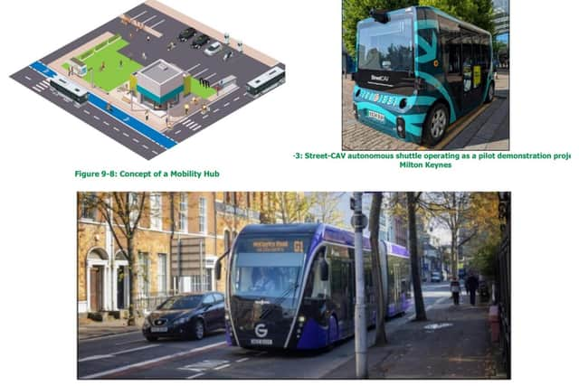
One of the longer-term ideas is a Northampton mass transit system.
The strategy looks at very light rail and trackless tram technology.
The report says a mass transit system would be “a step-change in public transport provision, beyond traditional bus services” and could take the form of a tram running on tracks or high-quality rubber-tyred vehicles designed to simulate the look and feel of a tram.
It says Northampton's built-up nature and constrained road network could make such a system challenging.
One option could involve converting a lane on a dual carriageway into a bus lane or dedicated trackway.
The report says a mass transit route could also have mobility hubs along it and potentially run from the town centre to the edge of Northampton.
It gives Belfast's Glider as an example of a trackless tram-style system, while also looking at Coventry Very Light Rail.
More orbital buses
Priority: Medium to Medium-High
The strategy proposes better bus connections between suburbs, including potential links between Grange Park, King's Heath and Sixfields, and between King's Heath, Kingsthorpe and Moulton Park.
Other orbital links are being considered between Moulton Park, Weston Favell and Brackmills, and between Weston Favell and Grange Park.
The report says the aim is to “better connect communities in the suburbs of Northampton”, allowing residents to make shorter journeys without travelling into and back out of the town centre.
For Moulton Park to Brackmills, the strategy suggests improvements to the cycle route alongside the A45 between Great Billing Interchange and Brackmills Industrial Estate, plus crossing improvements at Great Billing Interchange and Lumbertubs Interchange at Ferris Row.
The Weston Favell-to-Grange Park route could include walking and cycling improvements alongside the A45 and through Hardingstone and Wootton.
Passenger shuttles
Priority: Medium
The strategy also proposes passenger shuttle services linking Northampton railway station, the bus and coach station and Northampton General Hospital, and another linking the transport interchange with the University of Northampton's Waterside campus.
The schemes could initially use small buses, with the report also considering the possibility of future autonomous shuttle vehicles.
Rail
Priority: Low for the proposed Northampton Parkway station
A possible new Northampton Parkway railway station serving the south of Northampton is included for further feasibility and business-case work.
The strategy also looks at potential future rail connections and increased services following major rail developments elsewhere.
The report says the new station proposal is to “investigate the feasibility and business case for a new railway station serving southern Northampton.”
Villages and surrounding communities
Priority: Mixed, with the rural community transport proposal rated Low
Walking and cycling links are proposed between Northampton and surrounding villages.
The locations include Harpole, Little Houghton, Great Houghton, Milton Malsor, Kislingbury, Cogenhoe, Overstone, Wootton and Grange Park.
There are also proposed links around Buckton Fields, Moulton and developments east and west of the A43.
Other potential routes include Weston Favell to Wellingborough and King's Heath to Brixworth via the Brampton Valley Way.
The report says the package contains 12 interventions, including 11 green links focused on active travel and an investigation into a rural community transport zone using demand-responsive transport.
The proposed demand-responsive service could use mini-vans that residents request for journeys into Northampton which cannot be made by existing scheduled bus services.
The report specifically identifies villages including Harlestone, Church Brampton, Broughton, Overstone, Cogenhoe, Little Houghton, Great Houghton, Bradfield-on-the-Green, Piddington, Milton Malsor and Gayton as possible areas for such a system.
A council spokesman said: "The town is expected to see continued growth in housing, employment and town centre development, creating additional demands on the transport network.
“The draft Northampton Area Transport Strategy looks ahead to 2036 and beyond, identifying ways to support future growth, reduce congestion and give people more attractive alternatives to private car travel.
“It has been informed by evidence and people’s feedback, and sets out a vision to make walking, cycling and public transport more attractive and accessible.
“The draft strategy identifies a number of key challenges facing Northampton today, including barriers created by major roads, gaps in walking and cycling networks, limited bus frequency in some areas, poor bus and rail integration, and difficulties accessing key employment sites without a car."
How to have your say
You can have your say on the draft Northampton Area Transport Strategy by completing the online questionnaire.
If you need assistance to complete the online questionnaire, would like a copy of it in another format, or respond by an alternative method, WNC’s contact details are as follows:
Email address: [email protected]. Telephone: 0300 126 7000.
The consultation on the draft strategy is open until 15 November 2026. The final strategy will be taken for approval at cabinet in early 2027.