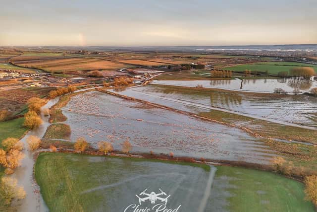
This badly flooded site is where they plan to build 5,000 new homes in Milton Keynes
and live on Freeview channel 276
A drone photograph has shown the extent of the flooding this week on the site of the planned MK East development, where 5,000 new homes will be built.
Specialist photography company Drove Over MK this week flew over the land, which is between Newport Pagnell and the M1, to record these images.
Advertisement
Hide AdAdvertisement
Hide AdMK East spans 461 hectares and, as well as the housing, will bring a community hub, a primary school, local shops and employment zones. It also will include a new 63-hectare ‘river valley park’ providing additional green space for residents.

The huge amount of infrastructure work needed means a section of the A509 from the junction with Newport Road to Cranfield and Tickford Roundabout (A422) was closed to traffic on 25 September last year and will remain closed, 24 hours a day, seven days a week, until Friday September 27 this year. Traffic must use the diversion route via the V8 Marlborough Street, onto H3 Monks Way.
Drone Over MK published the photos of the site on their Facebook page and they produced quite a reaction from the public.
One reader commented: “That area... has always flooded badly and regularly, and has done in the six decades I’ve been in the area. Any houses built without a periscope is going to have serious problems.”
Advertisement
Hide AdAdvertisement
Hide AdAnother wrote: “I think the people who live in Willen and Newport Pagnell may have been saying for sometime that this might be a problem...But then what would we know - have only lived in MK since 1975!”