
On Day 4 Barbara dropped me near Hardwick Lodge and I walked on to the A43 which is pretty difficult to cross. The way then led on through corn, pasture and set aside or fallow land with lots of wild flowers including clover, thrift and poppies and what people in my grandfather’s village in Leicestershire called eggs and bacon that is bird’s foot trefoil. Then away to the right I passed a modern (1990s?) country house with a small lake.
This was mostly downhill towards Holcot. To the left there was an event going on with a lot of people and cars. It could have been a car boot sale or a dog show. At one point there was the sound of a motorcycle revving up. At Holcot I had my lunch in a shady corner of the churchyard. There was a good display of hollyhocks there, a flower I have always liked. I think it reminds me of my grandfather’s garden. These were white and various shades of pink. There’s one on my allotment which is a pale yellow. I didn’t plant mine but I left it there because I thought it would attract the bees to my pea and bean plants. However the peas did not germinate. However beans look reasonably healthy so it might work.
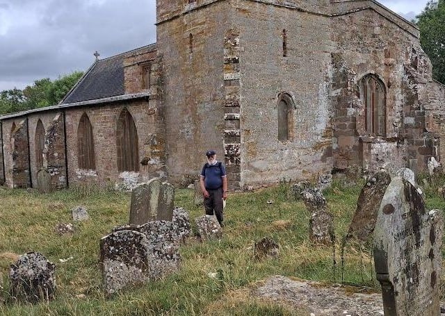
In Holcot Churchyard there is a collapsed grave stone, probably one of the altar shaped type. I found two inscriptions on it. One told me a man died in 190?, the last digit being obscured. It gave his name. The other was at such an angle that I couldn’t read it, but it gave the name of a woman in his family, possibly his wife or his mother. They must have been a family of some substance to have afforded an altar shaped tomb with a railing round it. Now the stones were in a jumble in the railed enclosure. “How are the mighty fallen! Tell it not in Gath. Publish it not in the streets of Asscalon….” (2nd Book of Samuel Chapter 1 verse 20)
The way then led down the road to the causeway over Pitsford Reservoir. Here I ate my first freshly picked blackberry of the year. Nearby I saw a black and white butterfly or moth I didn’t recognise. It could, I suppose, have been a large white. I know the females have black spots on their wings but I have seen thousands of these and there looked to be more black on the wings, or it could have been a cream spot tiger moth or a magpie moth.
I saw a squadron of water birds (young geese I think) swimming eastwards along the reservoir. There were six or seven line astern with two outliers on each side –forward to port and rearward to starboard. After a section along the north side of the reservoir the path rose towards Brixworth. This, like that round Finedon, is ironstone country. There were quarries around here until the early 1960s when the reservoir was filling, making the digging difficult. There was evidence of digging by rabbits very recently with lots of holes.
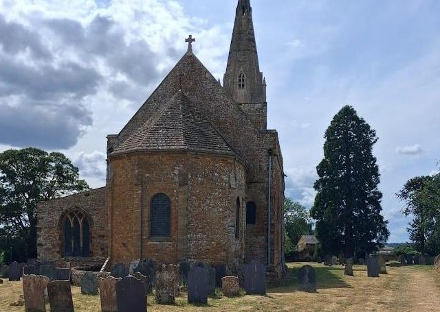
A section through some trees, a little difficult to negotiate, led into the north end of Brixworth where I made for the church, begun in the 680s or thereabouts and thoroughly worth a visit and several re-visits. I took some pictures of the east end. Professor Pevsner however tells us this bit was rebuilt in 1875 but there are remains of an outer crypt. Maybe one of my pictures shows this. I didn’t stop long, partly because there was a bus party there and I needed to get on to Chapel Brampton. I reached this partly by means of the Brampton Valley Way on its old railway track (the Northampton to Market Harborough line. Barbara met me there in the grounds of the Spencer Arms where I had an excellent pint
On Day 5 I was joined by Michael Brown, ”The Medieval Pilgrim.” I must thank Michael for a number of things, not just for keeping me company on the last two days of the walk and for helping with the transport ,but also for suggesting that I tackle this part of the Via Beata for my fundraising walk. He has had something to do with the course the Via takes in Northamptonshire, particularly in the eastern section. He also corrected me on one point on pilgrimages. The walk is designed as a pilgrimage. I was influenced by “the Canterbury Tales and dramatisations of it into thinking that many of the pilgrims rode horses or donkeys or even had carts, whereas they mostly walked. Moreover he turned out dressed for the part, as is shown in the picture. He drove us in his van to Chapel Brampton, where we started the walk for the day.
The first part of the walk was easy enough. The way was mostly a broad grassy track. Michael pointed out a field where “Fat Hen “(Chenopodium albuma) appeared to be being grown as a crop, probably for cattle feed. I’m all too familiar with it on my allotment. As a seedling it can easily be mistaken for peas and certain other crops. I read it is an important item of food for the yellow hammers I have frequently heard but not seen, for greenfinches and other birds. It was also in prehistoric times and later eaten by humans and still is in some places. Wikipedia calls it white goosefoot and gives several other names for it but I have never heard it called anything else but Fat Hen, or sometimes Old Hen.
Later on, after passing through some sheep and corn fields, the path went into uncultivated ground. All sorts of plants abound, mostly of little use to us but important for other species such as damsel flies, dragonflies and butterflies. At some time this ground was passed over by horses, possibly being ridden. They came this way in soggy weather and the holes in the ground had dried and became rock hard and walking is now therefore difficult if you don’t want to twist your ankle.
The Via Beata then joins the road to and through Ravensthorpe. It then leads on through good country to West Haddon. The path then led on to Watford across fields. In one place it was a little difficult to find as compared with the map, but this was good walking and I passed by some examples of that excellent modern invention, the wind-powered generator. But although there was quite a stiff breeze they were not working. The last section of the path before Watford was under a railway bridge of handsome design and along an avenue of oak trees through the Watford Court estate planted no doubt on the orders of the Clerkes or the Henleys or the Edens, owners of Watford Court years ago .
Barbara met us at Watford Church and drove us to Michael’s van and then me to home
Michael joined me again for the last day. Parking his van at Watford, we walked to Ashby St Ledgers crossing the M1 by tunnel, the canal by footbridge, the A5 on the level (in very sparse traffic for the A5) and the main line railway through a bridge under it. Later the waymarked path did not accord with what was on the map and we had to roll under the wire at two points. One small field was seriously overgrown before we got to a lane leading to the churchyard. Robert Catesby, leader of the gunpowder plot came from the mansion next door but much of the present building was designed by Edwin Lutyens in the early part of the 20th century. If you look over the wall from the churchyard you can see some fine statues in the mansion garden. Inside the church there is an interesting Jacobean pulpit, what looks like a medieval rood screen but with no statues of saints. There are also some faded but impressive medieval wall paintings.
The path from the other end of the village to Braunston was easy to follow and downhill much of the way. There was a tall mast or chimney on the horizon to the north west we couldn’t identify. The map showed a deserted village called Fawcliff a few fields away to the right. Another source calls it Braunston Cleves. Abandoned villages seem to be a theme round here.
Barbara, having parked the car, joined us for lunch at the Old Plough in Braunston, which was excellent and she joined us for the rest of the walk. . The rest of the walk was through a field on a tarmac path down to the main road, then over the canal bridge and onto a rough road past another abandoned village called Braunstonbury which is visible only as an area of humps and hollows in the field. There’s not much known about this village and it seems to have been treated as part of Braunston and is very close to that village. Bury meant a fort in Old English, which could mean Braunstonbury was the original settlement or the reverse. The name Braunston means the farm owned by a man (or a woman) called Brant. At the time of the Domesday Survey (1089), there were two manors at Braunston, one much larger than the other, but how this was spread over the three villages is not known. Fawcliff and Braunstonbury are not mentioned separately.
At the far end of this village we passed over the River Leam into Warwickshire and the parish of Wolfhampcote. The Church is ahead and to the left. This was our journey’s end apart from the walk back to the car at Braunston. The Leam is here a small brook, which rises near Staverton and flows into the Warwickshire Avon between Leamington and Warwick. We had crossed a watershed west of Ashby St Ledgers. To the east was the Nene basin where water flows into the North Sea, to the west the water flows down the Avon into the Severn and the Bristol Channel. To the right was another abandoned village (Wolfhampcote.) The remaining earthworks were quite impressive. There was a house we could see ahead and beyond that there is a farm. Those and the Church are all that there is left of the village. Could the existence of three villages (Wolfhampcote, Braunstonbury and Braunston) very close together mean that the available land could only support one village? It seems a reasonable guess. Two of them, probably gradually, got smaller as the inhabitants moved away.
Wolfhampcote Church is in a very quiet spot (like Little Gidding where I started my walk). There were sheep in the churchyard. The church was vandalised some while ago. There are no pews. The roof had to be made watertight. We met some people inside who were carving stone bosses to help in the restoration.
I felt a sense of achievement and thankfulness for being able to walk the distance. Apart from my feet hurting a bit I feel very well and physically and spiritually refreshed. I would like to thank my wife Barbara for her help in driving me to and from starting and finishing points and all the people who have sponsored me.
If you would like to make a donation towards the tour fund for the Choir of All Saints Church, Northampton you can do so via the Friends of All Saints Music Just Giving page at https://www.justgiving.com/campaign/Umbria25. If using this method please include “Michael’s Walk” in your message .
If you prefer you can send a cheque payable to Friends of All Saints Music to J Lowther, Friends of All Saints Music, All Saints Church, George Row, Northampton NN1 1DF Please write “Michael’s Walk” on the back of the cheque or in a covering note.